OUR SERVICES
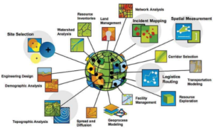
Our Goal is to provide Smart and Economic Solutions for Key Sectors i.e. Urban Planning, Agriculture, Forest, Water Resource, Transportation and Environment using Remote Sensing and GIS Techniques.
Creating data is the first step to build and manage GIS application. Digitization is the process of converting geographic data from scanned maps or satellite images into vector data by tracing the features as point, line or polygon format.
Geospatial also work in database management for various GIS database formats like file, personal and enterprise geodatabase.
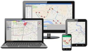
Our team can built customized apps for mobile data collection. The collected data is easily accessible for statistical analysis which saves the time as compared with paperwork.
The mobile app enables you to accurately record data, online or offline, by filling in digital custom survey forms. You can create an unlimited number of your own unique forms in the user-friendly form builder.

Geospatial works provide the services in configuration of Centralized GIS Database in Oracle, SQL Server, and PostgreSQL. Data is the most important thing in any GIS project. Geospatial team offers number of services to built spatial data as per the client requirement for analysis and decision making
We understand that each client have their own requirements. Expertise of our team in understanding clients need to come up with specific Web-GIS solution to make the work process easier. Our team is always updated with current technologies to choose best for our valuable clients.
We develop custom GIS applications for you that enables your organization to understand and visualize Geospatial data on simple GIS portal to optimize planning, decision making and enhance business operations

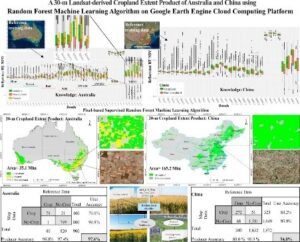
Processing of satellite and drone images and development of thematic maps for all related disciplines to empower them with clarity in decisions.